Enchantment Lakes 2003
In order to receive, one must be prepared to give. Few hikes have provided this example like my October 2003 trip into the Enchantment Lakes basin near Leavenworth WA. The pain and the pleasure of this hike were both pretty extreme, and I feel well rewarded for the strong effort that's required to see these sights. I can't say I felt that way about halfway there, though..
pre-hike
This was not my first attempt to visit larch trees in autumn.
My 2000 trip into the Icicle Creek area was foiled by a reluctant stove, which converted the hike to a car-camping trip. When this summer's Wind River trip failed to materialize in August, I put that week of vacation in my back pocket with larches in mind. Later, as I began to acquire materials in my back yard for other late-summer projects, I recognized that my schedule would be tight, and as September approached I watched both calendar and weather maps closely. My work schedule forced the vacation back a week, but that gave me more weekends for the back-yard projects so that was not a problem. A week before the trip I called the Leavenworth ranger station for updates; the larch were at their peak, permits into the Enchantment Basin were often available, and forecasts were holding up. Within a half-hour of this call, a co-worker signed himself out for the next day, announcing that he and a buddy were going to the Enchantments! That was a surprise, but it meant I'd have inside information before I left. My family helped with the yard also, so by midweek I was ready to abandon the yard for a few days. I called Mike to hear what he had learned on his trip, then packed for the trip. I was lucky to discover a food cache that was intended for the second June trip, which was postponed due to several of feet of snow; the sunflower seeds were too far gone, but most of the food survived for this trip. I finally headed out for the mountains on the last day of September. I set up for the night at the Eightmile camp along Icicle Creek, apparently the only camper there; that was similar to 2000 when I was alone farther upstream at Chatter Creek.
Wed 10-1
I arrived at the ranger station at 7:25 to await word on spare permits. Another Portland-area resident was also there; Larry had others with reserved permits waiting for him to find out his future. Others showed up as well, but they had advance permits also, so when the two of us heard that 11 permits were available we relaxed. A fire in the next valley south of our destination had apparently deterred others from the trip; seldom are eleven permits available for this area!! We listened to the restrictions (which included the risk of evacuation in two different directions if the fire flared up!), got our permits and headed our separate ways. [I had alternate plans for seeing larches, but this route is famous and my best hope for the trip.]
Mike had warned me of the rigors awaiting me on the Snow Lakes trail; at 8:30 I shouldered my pack and learned all about it. The route would take me from 1500 to 7000 feet in about eight miles, so very little subtelty would be apparent. The sun was shining on the road but not the parking area; as I wound up the narrow valley to the south, that sun would not catch me until 11:30! The trail snaked up the hill immediately, and a half-hour later I could still see the car (well, only the roof!). I ground on as best I could, and at noon I made it to Nada Lake. So far I had only seen one other person, but soon a few more were coming down the trail from their journeys. A set of sunny, sweaty switchbacks slowed my pace still more, and I reached the Snow Lakes at 1PM. I took a lunch break at the upper end of the lakes, cooking my dinner for lunch since I knew the trail was about to get worse as I got more tired.
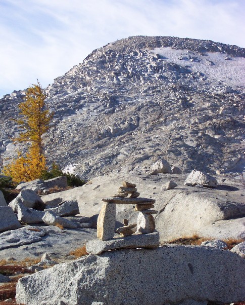
To refer to the final stretch as a trail is quite optimistic. It's often a duck-marked route on solid granite, which leans back at a slope of forty degrees or more. When it's a clear path it really isn't, as it is root-bound and treacherous - and still has quite a slope! I lost the trail for about 20 minutes at one point, finally going back to the last two ducks and discovering a third hiding downhill in the shade. I was taking many short breaks by now, but I could see across the valley that I was now among larches even though my companions were mostly fir and cedar. 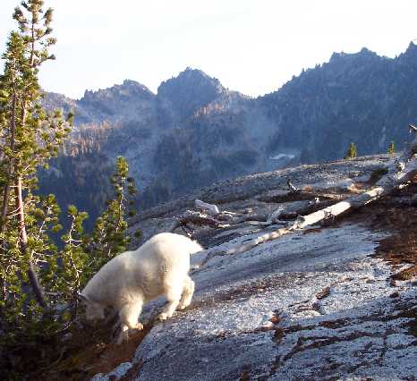 Finally I crested yet another granite slab and was staring directly at a mountain goat coming toward me; I barely got my camera out in time before he descended the hill about ten feet from me. Immediately after I encountered a sign telling me 'no campfires - Enchantment Basin' -- I had arrived!
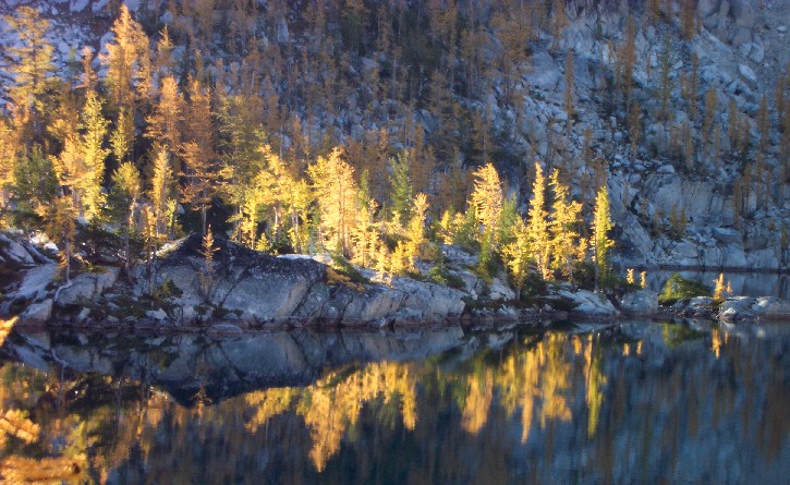
A few minutes later I stood by Lake Viviane, among the golden larch. No campsites reached out to me, and I knew that several lakes were pretty close, so I clambered goat-like up another hill and was confronted by an extremely enchanting scene. Larch slopes, larch islands, and a peninsula of the golden trees stood where the trail crossed the outlet stream; this was a place to camp! [While not marked on my maps, this was Leprechaun Lake - how appropriate for this Irish camper!] I found an exposed but comfortable site and dropped my gear at 5:10, too tired to seek a more out-of-the-way site. I munched on my lunch for dinner to complete the meal switch, set up my tent, and failed to sleep well despite my exhaustion. [I must figure out a better pillow, one that won't run away in the middle of the night!]
Thu 10-2
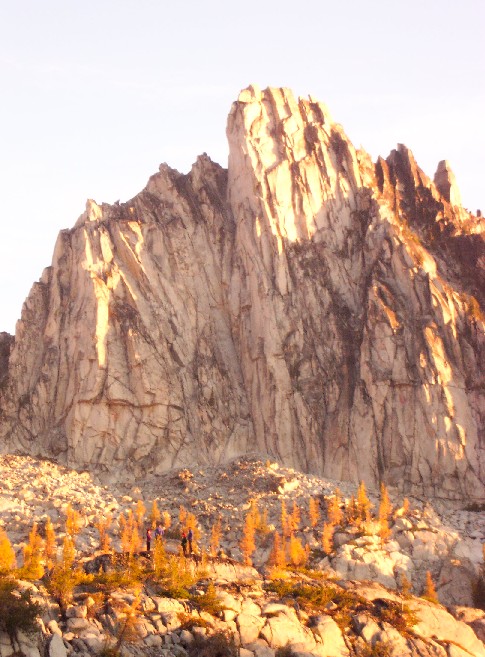
A pretty sunrise at 7AM brought me out of the tent for breakfast. I took a shot of Prussik Peak with four people in the foreground as I sipped my mocha.
 Thankfully, this was day-hike day; the pack would stay at the campsite. Trouble is, one of the warnings at the ranger station included protecting the pack from the goats - they love chewing the salty straps on abandoned packs!
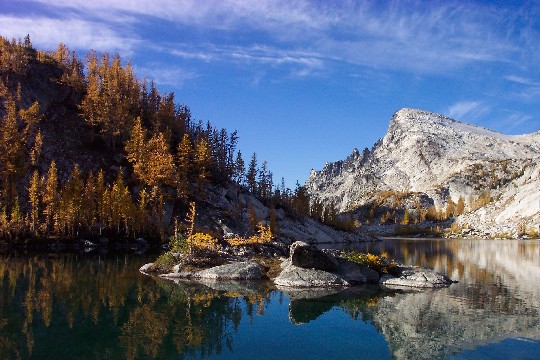
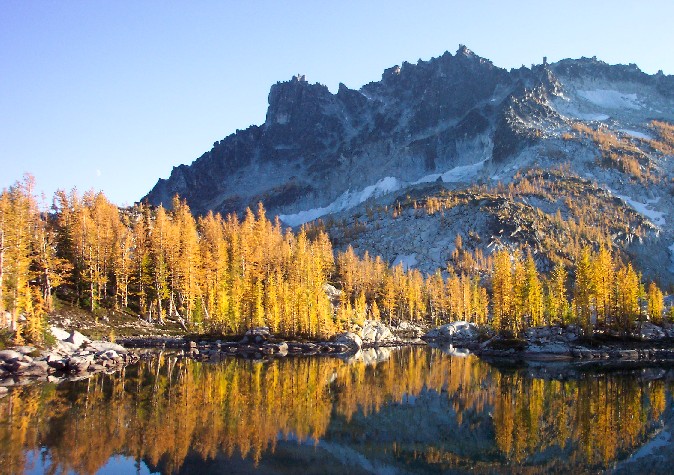
I put the pack inside the tent, zipped up pack and rainfly, and headed up the basin and further enchantment. Above Leprechaun Lake was a perfect small basin of tiny ponds and small rapids, with larch trees in abundance but not crowding the scene. Then above a stronger set of rapids, a larger tarn which sat about five feet lower than Enchantment Lake above, making for the ideal short-drop falls between the two. Enchantment Lake deserves to be named to match the basin, as it captures all the best of the area, including a view of Little Annapurna, one of the two best-known peaks in the basin.
Thankfully, this was day-hike day; the pack would stay at the campsite. Trouble is, one of the warnings at the ranger station included protecting the pack from the goats - they love chewing the salty straps on abandoned packs!
I put the pack inside the tent, zipped up pack and rainfly, and headed up the basin and further enchantment. Above Leprechaun Lake was a perfect small basin of tiny ponds and small rapids, with larch trees in abundance but not crowding the scene. Then above a stronger set of rapids, a larger tarn which sat about five feet lower than Enchantment Lake above, making for the ideal short-drop falls between the two. Enchantment Lake deserves to be named to match the basin, as it captures all the best of the area, including a view of Little Annapurna, one of the two best-known peaks in the basin.
 As the trail encircles the north side of the lake and continues up-basin, the other peak appears behind: Prussik Peak is a sharp spike from here, but it's also merely a big-time ridge on higher Temple Peak behind it. Another pretty lake is encountered above Enchantment, this one with big walls and several broken glacial remnants; the broken ice was extremely white since the top of the ice was dusty and grey in comparison. A steeper climb begins here, leading to a larger version of the tarn-and-rapid basin that I had met just above Leprechaun Lake.
 The elevation was leaving its mark, though, as the larch trees only made it about halfway up this valley. Below and to the left sat Crystal Lake, which is just south of Enchantment Lake but off the main trail; I believe it was off-limits on this trip anyway, as I would later see a helicopter scooping water from it to fight the fire to my south. The smoke from that fire was now more apparent as it drifted across the divide, making Little Annapurna and points west a bit hazy.
The ducks marking the route had become genuinely artistic, and on occasion I felt compelled to dismantle a few unlovely piles to improve their aesthetic value. I continued up to the next three lakes above this basin, believing that a few more were above that; I had misread the hand-drawn map the rangers gave me, though. Just above these three barren lakes I reached Asgaard Pass, the end of the basin; Colchuck Lake appeared practically beneath me, several thousand feet below! A route exists to reach it, but I don't want to know anything about that.
The elevation was leaving its mark, though, as the larch trees only made it about halfway up this valley. Below and to the left sat Crystal Lake, which is just south of Enchantment Lake but off the main trail; I believe it was off-limits on this trip anyway, as I would later see a helicopter scooping water from it to fight the fire to my south. The smoke from that fire was now more apparent as it drifted across the divide, making Little Annapurna and points west a bit hazy.
The ducks marking the route had become genuinely artistic, and on occasion I felt compelled to dismantle a few unlovely piles to improve their aesthetic value. I continued up to the next three lakes above this basin, believing that a few more were above that; I had misread the hand-drawn map the rangers gave me, though. Just above these three barren lakes I reached Asgaard Pass, the end of the basin; Colchuck Lake appeared practically beneath me, several thousand feet below! A route exists to reach it, but I don't want to know anything about that.
It was just past noon, and I had reached the trail's end; that didn't mean I had seen everything, nor even explored every trail! I retraced my route downstream, now encountering many other dayhikers (they probably slept better :-) as I went. At Enchantment Lake I visited with Larry for a few minutes. We both sought the infamous Gnome Tarn, a spot where notable photographs had been taken by famous folk; he had tried the path to Prussik Pass but found it had the wrong angle of the peak from there. Since I had seen the peak from higher up the path I had a strong idea that it would be found to the right of Prussik Pass, so I also went up that way. Just over the pass (with its view of Shield Lake well below) I found a rough path that went up and right; from there I had a point-blank view of Prussik Peak and could see the infamous tarn below and further right. I began to descend but had serious doubts about the sanity of the path, so after a while I thought better of it and retreated back to Enchantment Lake. From there I wandered back to camp, seeing the area in midafternoon rather than early-morning light; it was just as photogenic that way so I shot more of the same views. Back at camp I ate an early tortellini dinner and climbed the knoll that separated Leprechaun and Viviane lakes.
 The westering sun was sitting behind a small cloud, messing with several photographers' plans (including Larry again), but the sun finally escaped and lit the landscape with a warm and clear light. I grabbed my camera again and joined several shooters at the outlet stream. My digital camera had begun the day with over 90 exposures, but as it reached 12 I swapped in another chip with 75 shots available and kept composing. The sunset was wonderful, and the moon chipped in as it rose along the southern ridgeline. Finally the trees faded and I went back to camp, and another 13-hour night. This time I slept decently, which would serve me well on the cruel descent the next day.
Fri 10-3
Although I had thoroughly enjoyed the previous day, I must confess that part of my mind was occupied by the trip out. Having survived the cruel upslope with a heavy pack, I now had to make it gently down those same slopes without putting too much momentum on the downward steps! Larry had mentioned the same concern, but he had another day to play before coming out. I awoke to a frosty tent and a much chillier morning; that was the night I should have had the rainfly attached! I ate quickly but had to wait for the sun to defrost the tent and groundcloth before finalizing the pack. At 8:15 I reatached myself to the burden and began the trip out. Several spots were spooky but for the most part I found a good route. My bandana had disappeared late on day one, so I occasionally stopped to see if I had left it at the lost-trail site or later at the day-one lunch counter (turned out later that I had a photo of myself with it at Lake Viviane, so I lost it quite late on the first day). While at the lost-trail site I brushed away all lost footprints and placed a few sticks to bar the route; while finishing up an uphill climber began right up the wrong chute with his eyes down, so I guided him over and on his way. Many others soon followed, and it occurred to me that the Fri-Sun window was quite a popular one; another fortunate call on my part to be leaving before the crowds! Or was it? Many pretty women were ascending the mean trail, forcing me to admit that it would be nice to have someone to share the sights with in real time. Many were less than half my age, though, so I cheered them with whatever good news I could muster as they struggled up the hill in the late morning.
I was making decent time, and arrived at Nada Lake around 11:45. I had hit this spot on the uphill climb around noon and estimated that I should reach the car an hour faster than I had left it, or around 2:30. Several more folks were passed on the way down, many hoping they were near the lake; I told them how long it had taken me, which for many was not as reassuring as they had hoped! The relentlessly steep trail finally revealed the road and the roof of my car just before 2:00, and I reached my destination just ahead of schedule at 2:25. My legs were pounded to jelly, but Icicle Creek was a bit too far away for the anticipated soaking; I therefore proceeded to town, where I had a yummy ale at an outdoor table (for the other patrons' sake) along with a tasty meal. 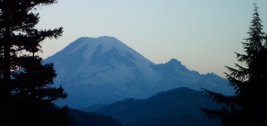 Thus fortified, I returned to Portland by the scenic route over White Pass, where I caught Mt. Rainier and the Goat Rocks as they paled just after sunset. By 9:15 I was home, with a soft bed, plenty of laundry, and about 180 new pictures to comb through for this web page.
What a trip! It was hard to believe that any view could be worth that climb while I was doing it, but the answer was clear the moment I spied Leprechaun Lake. The thought swiftly changed at that moment as I wondered at how few people had made the effort to see such scenery that nine permits had gone unclaimed that morning when I left the rangers. It would take a bit of coaxing from someone special to get me back up that trail, I once thought; now I believed I could be convinced pretty readily to do it again. Time will tell!