|
We reached the trailhead after noon, not an issue considering our short schedule
for this day. We wandered casually up the shady trail to the Wilderness
boundary, then emerged on the sunbaked slopes below Loch Leven for a bit of
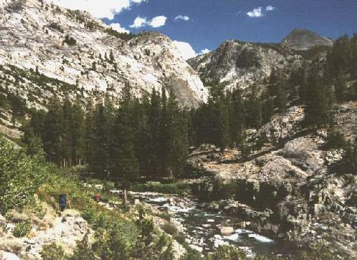
work. After a few short but warm hours, Larry and Julie found a very nice camp near the lower end of Piute Lake. A perfect,
cloudless day was our reward for the brief hard work we had done. We set up
early and ate our dinners well before sunset. I learned the hard way to read
labels more closely; while my dinner was quite tasty, the Mandarin Orange
Chicken had too much ginger for my system and I could not finish the meal.
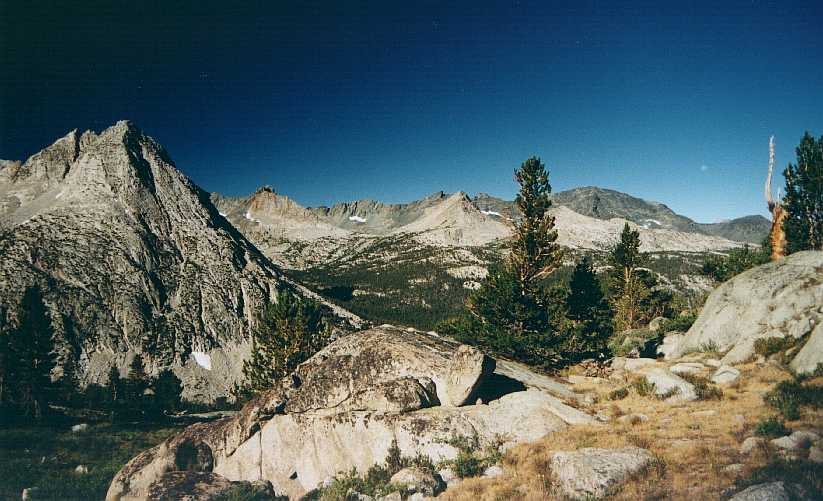
As twilight fell, Larry and I headed for the lakeshore for photo-ops while Julie
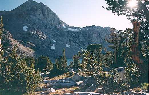
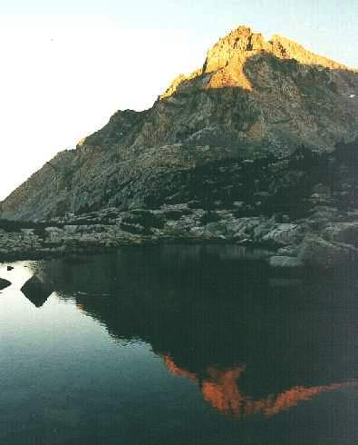
took her cold medication and prepared for bed. The unnamed peak 12600+ glowed brightly and reflected nicely, and was
joined shortly by the rising full moon. The altitude was effective in slowing me
down, but I felt exhausted enough to sleep well at our 11000-foot camp.
| |
|
Day Two
It took a great deal of effort to get up on day two! The altitude affected
my breathing all night, and I could not get comfortable from any angle. I kept
reassuring myself that the next two camps (as it turned out, all later camps!)
would be lower down and easier to tolerate; after a while this got me moving out
from under my rainfly and back into the world. Julie had fared worse due to her
cold, and Larry therefore was also not rested. We groggily packed up under a
typical cloudless morning and trudged upward.
As is usual with pass approaches, the views improved with each step. Soon both
Piute Lake and Loch Leven were revealed behind us, hovering over the brink of
the bench that led back to North Lake, while peaks of the Glacier Divide began
peeking over the low lip of Piute Pass. Several people passed us by as we
steadily ground out the last mile, confident that the downhill section would
follow soon. Among the passers-by was a woman with two llamas: a friend of
'sierramel', she was working her way down so she could support her friend
somewhere near Taboose Pass. As we reached our pass we encountered two men
relaxing there, 'fresh' from their climb of Mt. Humphreys. That's quite a
trophy, and the ragged mass of that peak dominated the northeast horizon while
we chatted with them. We finally re-shouldered our gear, said farewell and
dropped down to southern Humphreys Basin.
Another cloudless day revealed the Glacier Divide in all its ragged glory, and
soon we encountered someone who had just come over it somewhere. He referred to
his route as the Keyhole, but that name refers to a spot closer to Piute Pass
than his indicated route. Wherever he went, it was clearly spooky and
exhilirating! As we dropped nearer the treeline, a line of stones blocked the
trail and sent us left toward the Golden Trout Lakes. At the small upper lake
we stopped, ate lunch and pulled out maps - the main trail does not go here! We
concluded that whoever blocked the route before had some explaining to do; Julie
and I headed north and recovered the original trail while Larry went to the
lower lake and followed the creek to join us.
|
The grade steepened and dropped into the trees, and by late afternoon we were
hopping over the creek from French Canyon. All the guidebooks that warned me
about the tricky creek-crossings must have been written in June, since the
trickles did not get our boots wet. The Hutchinson Meadow junction was familiar
to me: I had reached here in '96 when my sore leg short-circuited our trip to
Evolution Valley and Lamarck Col, and we exited directly over Pine Creek Pass.
I remembered that a few campsites could be found farther down the canyon, and I
vaguely referred to a gorgeous memory of Piute Creek dropping three times in
succession. I wasn't sure any camps were near there, though, so we played it
safe and made camp by Piute Creek, within fifteen minutes
of the junction. We arrived early enough for me to wash some clothes, and Larry
pulled in a gorgeous golden trout that I captured with my camcorder. I had
purchased a two-day permit so my time wouldn't come until days four and five,
but my brother bought the 10-day and could fish anywhere, anytime - and he did!
Our camp was troubled by a few evening bugs, but again my tentless camp was
effective.
| |
|
Day Three
|
Morning brought some twisted cirrocumulus clouds with it, implying a bit of
upper-air instability. We hit the trail about 9:30 and headed toward the Muir
Trail along the spectacular canyon of Piute Creek.
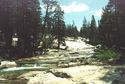
After passing a stock gate and a nice camp, we came to the stairstep falls that
I remembered from the '96 trip - but the view was even more spectacular than my
recollection! We took many photos from here, reveling in the great view and the
loud roar of the water in its canyon. That was the last decent camp for several
miles, as the canyon closed in with steep slopes and very few trees. We
literally bushwhacked our way through the manzanita as the canyon fell toward
the South Fork San Joaquin. The open slopes and lower elevation combined to
make the day warm up in a hurry.
The trail made its last moves along Piute Creek, and we soon reached the bridge
marking the Muir Trail junction and our entry into Kings Canyon NP. My memories
of this spot from the 1996 trip were of laying flat
on a rock looking at the clouds, noting through the haze of pain from my knee
that it wasn't going to rain on me that day. We sat in the shade of a huge
juniper and ate lunch, then prepared to move south for a few more miles. The
heat that had tickled us earlier now switched to a sledgehammer, beating on us
mercilessly as we struggled up the gentle trail. A few cumulus clouds had
formed this day, but not enough for shade or showers to relieve the heat. After
less than an hour of hot work, we dropped our packs and jumped in the South Fork San Joaquin for refreshment, a
brisk and thoroughly pleasant decision! A pack train passed by as we relaxed,
but they didn't seem to mind our packs by the trail - a good thing since we
weren't in any position to move them!
Thus reinforced against the heat, we regained our packs and
moved on, soon reaching the middle bridge over the South Fork and plenty of
welcome shade. The upper bridge appeared shortly thereafter, and we went
further up-canyon in the hope of finding a camp away from the Muir Trail
traffic. The best camp was already taken, and the trail began a steep climb, so
we retreated and found a spot about a hundred yards above the bridge. Another
cheerful fire was soon crackling away, and we went to bed in a good state of
mind.
| |
|
Day Four
We had postponed a decision on our final route until this point. We knew how
the trip would begin and end, but days four and five had several alternatives.
Would we head x-c toward McGee Lakes from Evolution Valley? If so, would we
pack x-c from McGee over to Sapphire Lake or backtrack to Colby Meadow? Or
would we forego those opportunities and continue on the Muir Trail? My two-day
fishing permit began today, so the lakes were appealing but certainly not the
only fishing-hole in the area. With all that in mind, we returned to the
Goddard Canyon bridge, crossed over the South Fork, and ascended into the
stunning gorge of lower Evolution Creek. The first stretch was warm and quiet,
with great views up and down Goddard Canyon framed by large mountain hemlock
trees. Crossing a slight crest, the roar of the creek took over, and the great
cascades showed their persistence by the great cavities carved into the hard
granite. Each bend in the trail brought new waterfalls into view, and no one
falls was superior in its beauty. My favorite stretch, however, was the creek just above the falls, where the stream stepped
down foot-high drops and whose gentle murmur was muted by the roar from lower
down. In a short while we were at the ford, which was not quite knee-deep at
the time. The darkening skies suggested that the level might be rising later in
the day, and soon a single clap of thunder echoed off the valley walls as we
passed Evolution Meadow. The clouds thickened further, but that single rumble
was as close to stormy weather we encountered.
I've noted on past trips that 10AM is the make-or-break point for Sierra
rain. If cumulus clouds aren't building by then they rarely produce rain, and
these had just come in at the wire.
|
| |
We met the local ranger at the next stock fence; he reassured us that the
forecast was for improving but cooler weather. Since Lamarck Col was tough
enough in good weather, this was very good news! We soon reached the ranger
station at McClure Meadow (my brother never never saw the place). The view from the
meadow was as just as advertised - spectacular shades of green contrasted
against the pale grey of the Evolution Peaks and the darker shades of the
clouds. Many small trout darted in the still waters of the creek, and silver
snags added yet another shade of grey as they lay in the quiet stream.
Julie was running out of steam, victimized by her head-cold; Larry suggested I
move ahead and scout out a camp. My first stop was near Colby Meadow, and the
site held great promise until I heard the shout from nearby. I looked across
the stream and straight into another camp, where someone was taking a
solar-shower; the privacy of this site was clearly compromised! I moved on a
little further, but now Evolution Creek was quite a distance from the trail. I
waited until we were all together again, then we dropped our packs and searched
for a decent site. Larry disappeared for quite a while, then returned to us
with news of a great spot. After ten minutes of wandering we found it again,
set up a nice camp by Evolution Creek, and discussed our options. We decided
our best bet was to stay here a second night, giving us a full day of rest
before tackling Lamarck Col. It would be a tougher day to cross the col from
this lower camp, but the day off would do all of us good. Larry and I tried the
stream for fish, and we caught and put back several small ones before returning
to camp for more typical camp food. I found it hard to concentrate on fishing
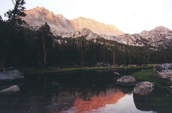
here - the massif of Mendel and Darwin dominated the
eastern sky, turning an amazing crimson at sunset, and the outflow from
Evolution Lake crashed into the valley a short ways off. The good news was that
our 9900-foot elevation allowed us to make use of the plentiful downed wood: a
pleasant fire contributed nicely to the ambience, and we turned in for a restful
sleep.
|
|
Day Five
|
This rest day would not be spent doing nothing! With Larry and I both ready and
able to fish, we all decided to day-hike to Evolution Lake and soak some flies.
Julie would join us as a tourist, using her skill to cook whatever we brought
back. We regained the Muir Trail with day-packs on (my new pack's top lid made a comfy daypack!"> and
worked our way out of the valley. At the last switchback I reached a symbolic
junction, where my northern and southern Muir Trail adventures were finally
joined.
It was great to see Evolution Lake again, but the wind was such that we felt we
would have better luck by heading for the peninsula in the middle. We worked
our way through abundant wildflowers to the peninsula, passing four younger
folks who were on a month-long visit to the high country. We caught the
attention of several fish as we worked our way around, but none fell for our
clever lines. We had been advised to use green-bodied flies for best results,
but I tired of the effort after a while and took a break by climbing to the top
of the roche moutonee, the geologic feature that makes up the peninsula.
The view was excellent from the top, and I panned from the summit with the video
camera. The scenery now included four young skinny-dippers, but I respectfully
left the camera on its wide-angle mode. The weather was much improved over the
previous day, and it appeared that our trek over Lamarck Col would not be
hampered by bad weather.
Returning to the shore, I selected a Renegade fly, a design that has always
proven successful wherever I go. I found a deep hole at the north end of the
peninsula and went to work. Not for long, though: I caught a 9-inch golden
trout on my second cast, and another about ten minutes later! The third one I
played with too long, and he spit out the fly and escaped. Several other fish
were on in the next hour, but my luck was over. Larry succeeded in landing four
fish while losing several others, and we felt that two fish apiece would make
for a decent meal. Julie had left an hour or more earlier, so we worked our way
back to camp late in the afternoon. Julie worked her magic, and the trout was
quite tasty!
Since day six would be longer from this camp, we scurried about during the
evening to prepare as many things as possible for an early start. We filled our
bottles and packed up as much as we wouldn't need for breakfast. As the sky
darkened, the far west went psychedelic: pale pastel clouds remained bright even
as the stars came out overhead. It was an amazing display of noctilucent
clouds, which I had only seen once before. These clouds form extremely high in
our atmosphere and are rarely seen, especially this far south. They are
distinguished not only by their appearance long before sunset or sunrise, but
also by their opalescent colors. This show had pale blue, pink and even some
pale yellow areas; I shot several photos using different shutter speeds to
ensure that the colors would come out. they finally faded about 8:30 and I went
to bed after a last visit to the warm and cheery fire.
| |
|
Day Six
It wasn't my best night of sleep, with the bright moon convincing me more than
once that twilight was imminent. Larry's alarm finally went off, and shortly
thereafter we did too. Several items conspired to make my day start badly - I
lost nearly half of my water supply when my pack leaned against the bite-valve
on my hydration bladder, I discovered several items were still sitting around
the camp, then I crushed my sunglasses while putting on the wet pack. My inner
fury over all the mistakes helped to get up the hill pretty quickly, however,
and within an hour we were at the Lamarck junction again. This time the link
was official: I had now connected my 1989, 99 and 96 trips into one continuous
stretch of the Muir Trail... depending on your Cartridge vs. Mather opinion.
|
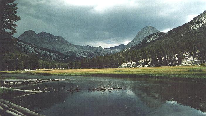
We followed the beaten track upstream, with views expanding southeast to
Evolution Lake and southwest into the unexplored McGee
Canyon. We lost the uphill path in the same place that Scott and I had lost
it a year before, then found ourselves at the lowest and largest Darwin Bench
lake. I refilled my half-empty water bladder, and while there we noticed
several fish that appeared to need dragging from the water. If we'd had more
time this day we might have made the attempt, but we were thinking about heading
all the way to the car; Julie's head cold was no better, and she had had about
enough of sneezing in the wilderness. My brother and I are sensitive guys, and
while our original plan of making one more camp would make a great place to eat
and fish, we emphasized with her condition and agreed. [By doing this we added
two miles on both ends of day six!]
|
| |
At this point I was still deluding myself that I was guiding the trek over
familiar terrain, and that my experience would make the exit route easier than
the '99 visit. This delusion was quickly shattered as I pointed out the trail
along the lakeshore, noting that the 'real' trail must go further right since it
passed by our camp last year further east than the lakeshore trail. This led us
into large rocks with no path at all, and as we scrambled over this terrain I
loudly doubted my sanity. Julie and I returned to the waterside path while
Larry remained to the right as we climbed upstream to the first of Darwin
Canyon's five lakes (we never did spot the '99 camp, much less another path).
Larry joined us just below the lake, where we noted several foot-long trout
trapped in a small pool on the stream. These were subsantially larger than our
dinner the previous night, and it didn't seem fair that they would show up
here!
When we reached the shore of lake one, we took a break and prepared ourselves
for the talus-hop around the lakes. The weather was cool but gorgeous, and no
cloud would be seen this entire day. Larry and Juile watched me negotiate the
first few rocks, and Larry said no-thanks and headed up a slot to the left.
Another slap to my guiding prowess for this route, but I didn't like my route
either, so I headed uphill with them. After cresting the low hill we could look
down to the lakes, trying to find our next direction. The trail below us was
less troubled by talus, so I descended to familiar ground while Larry tried to
stay high and Julie took a middle route and joined me in a few minutes. The big
talus drove Larry down as well, so we all met at the low end of lake two.
The second and third lakes were easily negotiated by the trail, and we rested
again between lakes three and four. Here I noted that the route would get ugly
for fifty yards or so, but no other route looked any better. We scrambled
through the mess of huge rocks, reloaded our water bottles, and headed toward
the turn between lakes four and five. By leaving my filter cover by the lake,
Larry and Julie got a several-minute lead while I wasted still more time getting
set to move. They were a hundred yards or so ahead of me when I shouted
instructions as to where the col was on the skyline. This careless comment was
costly, as my description was given from a point nowhere near their view; my
'pyramid-rock' guidepost was not the same as theirs and they veered to the left.
They hit big rocks and slowed down, allowing me to catch up a bit and ask why
they were so far left: their answer clued me in to my careless instruction, and
we all swerved back to the right over a rough and rocky ridge. The route
continued to be more elusive than the previous year, as good pathways in the
sand led to more huge talus, but we continued upward at the best pace we could
manage. Two hikers were working their way down from the col, taking a route
more to our right; just as we considered going that way we saw them working
through a tough stretch and decided to keep on our course. Finally, well after
2PM, the narrow notch that is Lamarck Col greeted us - from here the path would
be much more visible!
| |
We had plenty of miles to cover from the top, and the chill breeze was not
conducive to a long delay, so after fifteen minutes of
dining and photography we were under way again. The permanent snowfield
that reposes under the northeast lip of the col was larger this year, and the
suncups were impressive; a good twenty minutes was spent carefully sliding down
to another high, sandy valley that is much less steep than the side we had
ascended. We then shifted into a higher gear, working our way down the long
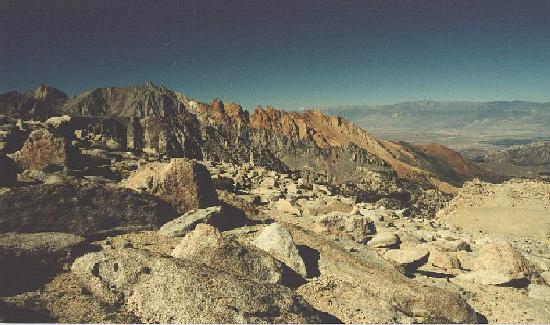
valley toward Grass and North Lakes, now visible in the near distance. The view to the northwest was a psychadelic display, with the
rusty red Piute Crags contrasting mightily with the greys and off-whites of
nearby ridges and distant Humphreys. We lost the trail once again near the
bottom of the valley, but this time I knew that the trail visible to the left
was the proper route. Shortly after that came the 'vertigo path', where a brief
slip could induce heart failure and a fall would last a long time. We hustled
carefully through here, then began down the long switchbacks above the Lamarck
Lakes trail. I stopped at the top of the switchbacks to change film in my
camera, began to descend, then slipped and skidded to a nerve-wracking stop a
short way down the slope; as a result I fell behind the other two. Larry
decided to speed up some more and bring the van to the trailhead, saving us a
bit of time. This was a good idea gone wrong, as he took the abandoned trail to
lower Lamarck Lake and had to wait for us to pinpoint the real trail's location
in front of him. He climbed a spooky cliff and rejoined us, then sped off again
as Julie and I worked down the switchbacks above Grass Lake.
|
| |
While my leg was far less damaged than the previous year, the long day was
slowing me down a great deal on the downslopes, so Julie put a bit of a lead on
me. This final stretch seemed interminable in '99 and if anything seemed worse
this time, so I was glad to hear the two of them ahead of me: done at last? I
was not alone in feeling this trail had gone on too long: they were resting on
the trail, and Larry suspected that we were on the wrong trail. Surely it
shouldn't take this long to travel a few short miles! I reassured him that this
was the right way, that it seemed infinite but familiar to me as well, and we
continued on together. It seemed like only a few short decades later when we
reached the picnic-table that Scott had collapsed on the previous year, and soon
afterward we reached civilization again. Larry went down to the van while Julie
searched in vain for the beer that Larry hid in the creek a week before. The
van pulled up, we dumped our gear in back, and Larry found the beer. After that
tasty treat we hit the road, pulling into Bishop at dusk. We had just put in a
12-plus-hour day, and we were clearly exhausted - and HUNGRY!
|
|
Epilogue
We found a nice motel in Bishop, then sped northward to Medford the following
day. We detoured into Mammoth Lakes on the way, then had a quick meal in
Bridgeport. I convinced them to take the road north out of town, which would
return us to US 395 at the CA/NV border. It was a beautiful route, with the
East Walker River and the Sweetwater Mountains showing off along the route. The
surprise of the drive was in the middle of nowhere, in sagebrush and scrub
willow country: a milticolored black bear loped along the side of the road,
setting a good pace as we slowed down and scrambled for cameras. Just as Larry
and I got set (Julie was driving at the time), he crossed the road and crashed
into the shrubbery. Of all the places to see a bear, this was among the least
likely!
We had heard that Oregon was receiving some welcome rain, and as we approached
Susanville the clouds appeared, looking more menacing than usual. In fact this
was no storm at all, but smoke from a rapidly-growing fire in the Feather River
canyon (this would still be burning when I wrote this, a week after Labor Day).
The sky turned brown, the sun a shade of crimson - but in an hour we had passed
through the smoke and back into the clear.
Peggy welcomed us back to Oregon even though it was after 10:30 when we reached
her. Tom had taken Sara to a SF Giants game and was not home yet, so we filled
Peg in on out adventures before turning in. Sunday was a tedious but
straightforward drive home.
SUMMARY
This was a fun hike, a decent workout without the risks of the '99 trip. Larry
and Juile are easy to get along with, and our paces are similar but not such
that we march through the wilderness in lock-step. Julie's discomfort was tough
to watch, and I symphatised with her camera issues (several times her camera
refused to shoot, explaining with descriptive notes like 'H3' and 'H5'...). She
did as well as any over Lamarck Col, though, so clearly she had the strength to
fight through her cold; would I do as well under those conditions?
The fishing was great fun. I hadn't fished in several years, and my technique
showed it; nevertheless, it was relaxing and somewhat productive as well. Those
golden trout are amazing in their technicolor splendor! All the new gear worked
fine, and I lost a bit of unneeded weight by the end of the trip.
And yet...
Something about this trip was less fun than previous outings. Part of it may
have been the anticlimax that any trip would entail after the ambitious '99 trip, but I suspect that
overplanning was also to blame. Much of this trip could be found in outlines
for 1993-4-5-6 trips, so I had visited these places in my mind countless times.
I tried not to overanalyze this one, yet our uncertainty up to the last minute
kept me thinking about route variations for the middle days of the trip. (Even
with all that, our final route was not on my mental map, so plenty of energy
went for naught.) Our poor preparation for altitude was also unpleasant, since
our long drive immediately before the trip left no time for much exertion in
thin air. My disastrous final morning put me in a bad frame of mind, and the
continuous irritants from leaky liquid containers was decidedly unpleasant. I
also ran absurdly low on toilet paper, which made me all the more agreeable to
packing out a day early. Technical difficulties such as these can turn a
relaxing and scenic trip in fair weather into a trip where misfortune is
anticipated around each bend in the trail.
I still can't understand how the route up Lamarck could be so easy in '99 but so
complicated a year later. That was as tough a hiking day as I can remember,
going from 9900 feet to 12900 to 9500 in about eleven miles and over twelve
hours. I know I've done tougher days, but they have respectfully faded in my
memory compared to this.
I can now cross Lamarck Col off my list of things to do, having crossed there in
consecutive years. It's bizarre to think that, of all the passes available in
the High Sierra, I have crossed Taboose Pass and Lamarck Col twice! I still
need to work Bishop Pass into a route, which would complete the east-side
entries into the Middle Fork Kings area, but with so much yet to see in the
Sierra I can't imagine returning to this particular area soon.
|
|
|
|
|
 We reached Bishop with plenty of time to spare, stopping at the amazing Convict
Lake along the way. By now it was clear that Julie was carrying extra weight, a
cold her daughters had caught the week before. We ate a good breakfast, bought
fishing permits and cold medications, and pushed the car up the steep highway
168 toward Lake Sabrina.
We reached Bishop with plenty of time to spare, stopping at the amazing Convict
Lake along the way. By now it was clear that Julie was carrying extra weight, a
cold her daughters had caught the week before. We ate a good breakfast, bought
fishing permits and cold medications, and pushed the car up the steep highway
168 toward Lake Sabrina.