
Just before leaving on this vacation, I heard a paraphrase of the above quote in the movie 'the Eiger Sanction'. This quote came in handy once or twice in 2004!
Preparation
Commute
This trip began in the springtime as a possible jaunt from Shepherd Pass to the summit of Mt. Whitney,
a spot that my brother had coveted for some time. As time went on it appeared he would not be able to
attend, so our attention shifted to Bishop Pass and a portion of Roper's Sierra High Route from Dusy
Basin to lower Palisade Lake. The cast of characters also continued to shift, until the prime proponent of
this trip also was forced to withdraw. We three who remained left the trip intact, feeling that with
two guidebooks to reassure us we could handle the route. The cast in fact did include my brother Larry,
and also co-worker Kristine, who would backpack in the Sierra for the first time. Not just that, though: she
had never hiked at elevations above even the trailhead at South Lake, much less at 12000 feet - nor was
cross-country travel in her repertoire! We all knew her experience in the Northwest and elsewhere had
qualified her, and her enthusiasm would also serve her well.
On the Saturday of Labor Day 2004 we headed south from Portland, headed in some fashion toward
Alturas and a pre-reserved motel. We chose a new path to get there, heading first to Medford
then due east by Lake of the Woods to Klamath Falls and south again. That route was beautiful and
included two bald eagles besides the usual great Cascade scenery. The following day was another long
drive, ending in Bishop for last-minute preparation before heading to a reserved camp high on the south
fork of Bishop Creek. We set out a few things, tightened our shoelaces and headed for a warmup day-
hike toward Treasure Lakes. We ran out of time before encountering the lakes, though, and returned to
camp as the light began to fade. The camp was fine but chilly, which portended even colder camps to
come as we gained elevation!
DAY ONE DAY TWO
The view south from Potluck was much worse than expected: an apparent vertical drop of a hundred feet or more
greeted our toes, and views of the lake were somewhat inhospitable for camping. Behind that stood Cirque Pass,
an ugly mass of lumpy slabs that also looked unappealing. We were already tired from a long day of travel,
so it all looked worse through the haze of exhaustion and a little altitude-adjustment lag by our sea-level
bodies. Kristine walked partway down the 'fortuitous slab' that guidebooks tout as the key to this pass, then came
back higher while Larry and I took a look. As titular leader of the tour, I felt I needed to speak first to set
the tone, which was a bit flat. "I've done worse", I said, "but I'm not proud of it." [That would be Cataract Creek Pass in 99]. Kristine was uncomfy but would follow if Larry and I
were willing, and Larry was in fact willing. I then mentioned that Cirque, the next pass, sounded like the
toughest of the three; if this was spooky, would we really want to camp at the lake with these two choices
to get away? Larry had read the same books (mine), and Cirque indeed sounded messy. We contemplated the descent
from the lake directly downhill to Deer Meadow, but (a) that route had looked just awful in '99 from the other side,
(b) it was a 3000-foot x-country descent (with willows), and (c) we hadn't studied that page in the book. We
debated for a while longer, fretting as the time sauntered by, and with reluctance decided that no real
happiness awaited us on the road forward; we therefore turned back.
Our consolation prizes reappeared below, a pretty lake basin that appeared from the topo map to be a simple
enough descent from Potluck. Soon however we were stranded on a cliff of about 40 feet, looking down longingly
on the highest lake and the small but welcoming trees just below it. Another hour was wasted, and we were
still nowhere near camp. This further emotional beating was taking us to our respective breaking points as
we headed uphill toward the not-Potluck pass once again. We found a tiny creek just at the crest and, despite
standing at 12000 feet, we decided this was our camp for the night.
One last indignity capped the long day: a midnight call to the facilities. This is an awful way to spend
any part of the night, and midnight is seldom a good time to do anything. Sure enough, I became lost on the
way back to our camp - even with nothing but rocks blocking my way! I was about to call out after scrambling
for fifteen minutes and getting chilly, but at last my lamp reflected off some super-reflective tent fabric
(thanks, MSR!) and I soon was back in my bag - chilled, thirsty, and ready to stew just a little more.
DAY THREE DAY FOUR
My unhappy knee kindly allowed the entire descent to the Muir Trail, to the relief of all of us. The grade is steady
but not unreasonable, and the Dusy Branch is usually nearby, whether dashing madly or simply sliding downslope with
a steady hiss. The clouds had built up this day, leaving mottled sunshine to highlight selected peaks or basins as
we lost elevation and descended to real trees for the first time on the trip. By midafternoon we were at the
bottom, chatting with the ranger about nearby campsites, weather and other matters (Larry recognized him as the ranger
at Evolution Valley in 2000!). We were steered to a nice campsite, with two good flat spots - Larry improvised his
tarp over a very small third site. In this narrow, U-shaped canyon the sun was down very early, but reflected sunlight
was sufficient to let us stay up as late as in our 12000-foot camps. And yet again we were pestered by the minimum
amount of wildlife: a few mosquitoes were all that joined us here.
DAY FIVE
Now provided with a new goal, we worked our way swiftly past Bishop and Saddlerock Lakes, then Long Lake. At last we
reached our first prime objective: that homegrown ale soaking in the stream! I stuffed it into the outside pocket on
my pack and we continued onward past the Treasure Lakes junction. The sun had fallen below the high peaks again, but
it was only about 4PM when we finally reached pavement. A few last photos, a long-hidden car key, and a bottle-opener
soon followed, and we partied at the car for a while to celebrate our accomplishments. By 5PM we were back in Bishop,
seeking motel-rooms and salads!
We awoke to a chilly morning, but soon had enough food and clothing to stay warm. We drove to the South
Lake parking area, found a place to park, and bade farewell to civilization for a while. Larry hid some
ale in a nearby creek, and we stuffed a bottle of home-brew in his side pocket for the next higher creek.
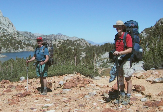 We then began working up toward Bishop Pass and found to our surprise that no cool creeks crossed our
path for quite some time! We finally reached a stream, hid the bottle, and continued to the higher lakes
in the basin. Long Lake lived up to its name, as did the Timberline Tarns (such rampant creativity!).
We then began working up toward Bishop Pass and found to our surprise that no cool creeks crossed our
path for quite some time! We finally reached a stream, hid the bottle, and continued to the higher lakes
in the basin. Long Lake lived up to its name, as did the Timberline Tarns (such rampant creativity!).
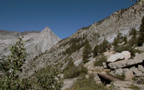
 Soon we were climbing a massively-constructed set of switchbacks drilled into the rock below the high
pass, marveling at views of Bishop and Saddlerock Lakes and the Inconsolables that raggedly pierced the
sky to our east. Mt. Agassiz was the tallest of the bunch here, and its spur marked the location of our
pass. Soon we were on top, admiring the view of the peaks around Dusy Basin while snacking on lunch.
The basin itself is quite convoluted, so the view below was restricted. After our snack we worked our way
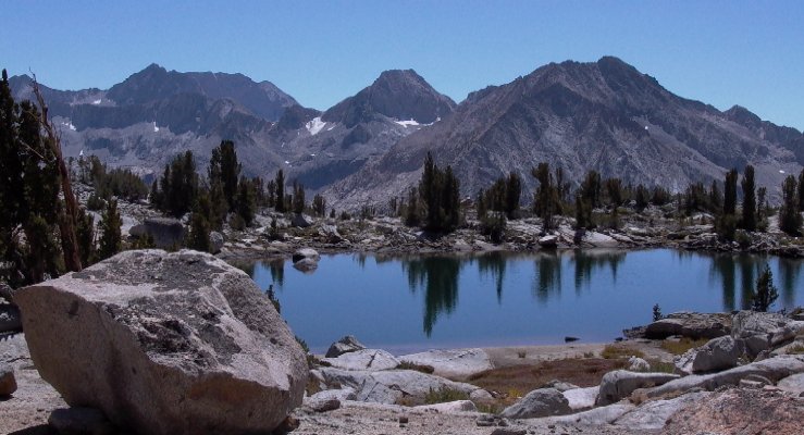
into the basin, and encountered the first of three high lakes that we hoped would prove welcoming for our
first night. We stopped near the second lake (actually several adjacent ones) and found a good spot. A
chill breeze was keeping us concerned about how cold the evening would get, but despite that I rolled my
warm sleeping-bag beneath the darkening sky and slept under the wheeling stars that night, finding the bag
to be more than warm enough to defeat the chill.
Soon we were climbing a massively-constructed set of switchbacks drilled into the rock below the high
pass, marveling at views of Bishop and Saddlerock Lakes and the Inconsolables that raggedly pierced the
sky to our east. Mt. Agassiz was the tallest of the bunch here, and its spur marked the location of our
pass. Soon we were on top, admiring the view of the peaks around Dusy Basin while snacking on lunch.
The basin itself is quite convoluted, so the view below was restricted. After our snack we worked our way
into the basin, and encountered the first of three high lakes that we hoped would prove welcoming for our
first night. We stopped near the second lake (actually several adjacent ones) and found a good spot. A
chill breeze was keeping us concerned about how cold the evening would get, but despite that I rolled my
warm sleeping-bag beneath the darkening sky and slept under the wheeling stars that night, finding the bag
to be more than warm enough to defeat the chill.
The morning was cool but not desperately so; the main problem was the Palisades. Those ragged 14k peaks
kept the sun away from our camp until about 8AM! We finally got started, remaining off-trail in an attempt
to reach the base of Knapsack Pass without dropping to the lowest lake in the basin to do so. While we did
succeed at this, we were on a willowy slope; these Sierra nemeses tend to leave welts and hide the ground well,
so they can be quite miserable for a descending traverse. We did save a little elevation though, and soon we
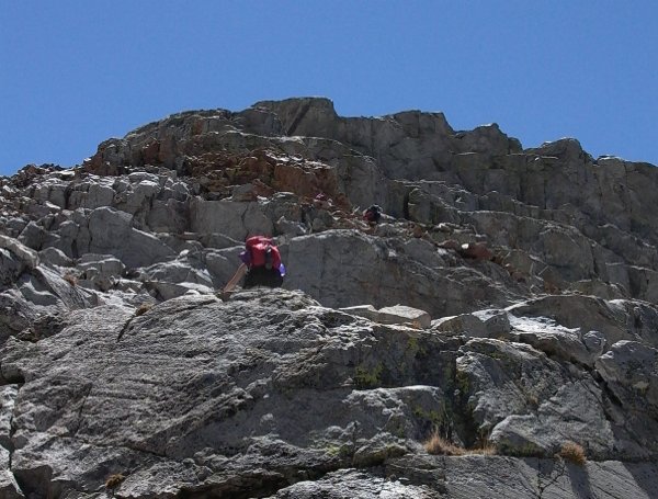
were ascending a steep and somewhat tricky gully - this is not class-one hiking by my standards, and I
was disappointed in the Secor description as such. Once above this space we were on wide slabs to the top, a
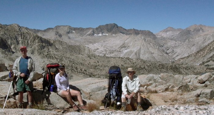
much easier arrangement. Soon Kristine stood at her first cross-country summit, and Larry and I gained a new one:
11670-foot Knapsack Pass. It was a fine view northwest toward Black Giant and the Muir Pass area, and we took
a group photo with that region behind us.
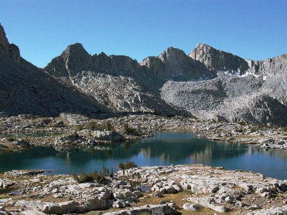
 The Barrett Lakes were well hidden from the pass, but soon we uncovered a lake or two after a short but
fairly easy descent. We bypassed the two large lakes, admired views of both North Palisade above and a
few HUGE trout below, then ascended the off-color slabs that lead to .. not-quite-Potluck Pass, a notch from
which one must traverse and ascend slightly to reach the actual pass. Soon after 3PM we were there, with
plans to descend and camp at the large lake below Cirque Pass.
The Barrett Lakes were well hidden from the pass, but soon we uncovered a lake or two after a short but
fairly easy descent. We bypassed the two large lakes, admired views of both North Palisade above and a
few HUGE trout below, then ascended the off-color slabs that lead to .. not-quite-Potluck Pass, a notch from
which one must traverse and ascend slightly to reach the actual pass. Soon after 3PM we were there, with
plans to descend and camp at the large lake below Cirque Pass.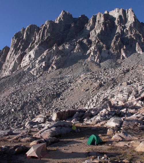 While each of us was suffering in our own way at the twists of fate this particular afternoon, as 'leader' I
was really low. I had sold two nice people a route that I was unwilling to take myself! They reassured me
that it was a group call and not mine to make; that was good to hear, but I had made an emotional stew which
I felt compelled to simmer in for a while. The camp was nice and flat, the water sparse but sufficient, and
our hunger after this long day was pretty strong. The chicken stew was just right, and soon we were preparing
for the long night ahead; this time I pitched my tent's rainfly for extra heat and wind protection, but if
anything this night was warmer than the last one.
While each of us was suffering in our own way at the twists of fate this particular afternoon, as 'leader' I
was really low. I had sold two nice people a route that I was unwilling to take myself! They reassured me
that it was a group call and not mine to make; that was good to hear, but I had made an emotional stew which
I felt compelled to simmer in for a while. The camp was nice and flat, the water sparse but sufficient, and
our hunger after this long day was pretty strong. The chicken stew was just right, and soon we were preparing
for the long night ahead; this time I pitched my tent's rainfly for extra heat and wind protection, but if
anything this night was warmer than the last one.
We awoke late, exhausted from the previous day's work and awaiting the slow-rising sun as it climbed the
Palisades. We were now a party without a specific itinerary but, creative souls that we are, we soon
had a plan: find the back door to those lakes that refused us entry the night before! Soon we were
circling the largest Barrett Lake again in search of that other entry. Another distraction intervened
first, though, as another large trout caught our eyes in that lake. Larry broke out the fishing gear
for a while as Kristine and I snacked and observed. The fish were large for a reason: they were very
skittish of movement on the shore, and after a while Larry accepted fate and we continued on. We dropped
to the skinny lower lake in the high basin, then contoured slightly lower to previously-hidden gems.
These were not our goal, however, and we skirted them, crossed another rise, then dropped and turned left.
There before us were our little gems that had beckoned to us from Potluck the previous day; ten minutes
later we were among them, seeking a camp for the night!
 While camps at first proved scarce, bear scat was found in abundance! Fortunately, the poop made two things clear:
1) it was all quite old and dry, and 2) grass was by far their primary food source - no freeze-dry food,
snack foods or (worst-case scenario!) bear whistles and bells were in evidence. We soon had a prime camp
set up in the basin, from which we dashed off to the small lakes to rinse our tired bodies and bask in the
sunshine. This day was almost as easy as the previous was difficult, and we felt absolutely no guilt as
we reveled in the relaxation that we had earned. A bit later, Larry and Kristine headed for the higher lake in
the basin while I relaxed a little more at camp; they returned with enthusiastic stories about the area.
We then spoke of the next day's plans - Kristine really wanted to see the bottom of LeConte Canyon, which was
on our original route but no longer part of a simple loop. Hearing no objection we agreed unanimously
that LeConte was our next goal, and since Larry simply wouldn't allow me to miss that upper lake he
guided me there now while Kristine remained at camp. It was a short hike to a pretty basin, with layered
granite slabs that were stacked like dinosaur vertebrae, and huge symmetrically cracked slabs that
gave the appearance of a ruined city. We soon returned to camp for dinner (passing a nearby sandy-floored
crevice that looked absolutely perfect for a winter bear-refuge!), taking more images as we went. Soon night
was descending yet again, and I again stretched out with only the stars for cover.
While camps at first proved scarce, bear scat was found in abundance! Fortunately, the poop made two things clear:
1) it was all quite old and dry, and 2) grass was by far their primary food source - no freeze-dry food,
snack foods or (worst-case scenario!) bear whistles and bells were in evidence. We soon had a prime camp
set up in the basin, from which we dashed off to the small lakes to rinse our tired bodies and bask in the
sunshine. This day was almost as easy as the previous was difficult, and we felt absolutely no guilt as
we reveled in the relaxation that we had earned. A bit later, Larry and Kristine headed for the higher lake in
the basin while I relaxed a little more at camp; they returned with enthusiastic stories about the area.
We then spoke of the next day's plans - Kristine really wanted to see the bottom of LeConte Canyon, which was
on our original route but no longer part of a simple loop. Hearing no objection we agreed unanimously
that LeConte was our next goal, and since Larry simply wouldn't allow me to miss that upper lake he
guided me there now while Kristine remained at camp. It was a short hike to a pretty basin, with layered
granite slabs that were stacked like dinosaur vertebrae, and huge symmetrically cracked slabs that
gave the appearance of a ruined city. We soon returned to camp for dinner (passing a nearby sandy-floored
crevice that looked absolutely perfect for a winter bear-refuge!), taking more images as we went. Soon night
was descending yet again, and I again stretched out with only the stars for cover.
No bears returned to their haunts to disturb us, and we were up before the sun (which chose yet again to climb
the nearby peaks before illuminating us!). We had another full day planned if we were to cross Knapsack Pass
again, reach the trail and descend to LeConte Ranger Station, so after a hasty breakfast we retraced our steps
away from our favorite camp of the trip (well, mine at least!). Soon we were below Knapsack, approaching from
a distinctly different angle, but we ascended with minimal difficulty and were again on the high slabs. We
gently descended the lower gully, then continued down to the long lake at the bottom end of Dusy Basin. During
this descent my occasionally-sensitive knee began speaking loudly to me, warning of impending miseries if I kept
up this x-c descent.
 I told the others at the lake that I was in some pain, and that our plan was at risk. Soon,
however, we reached the trail, and fortified with ibuprofen I continued gingerly down the trail. They agreed to
stop if I began to weep, and with that reassurance we all worked our way past the slow pools of the Dusy Branch and
began the long walk into LeConte Canyon.
I told the others at the lake that I was in some pain, and that our plan was at risk. Soon,
however, we reached the trail, and fortified with ibuprofen I continued gingerly down the trail. They agreed to
stop if I began to weep, and with that reassurance we all worked our way past the slow pools of the Dusy Branch and
began the long walk into LeConte Canyon.
Another day, another goal: this day's plan was to cross Bishop Pass and camp among the high lakes just beyond, thereby
giving us more time to drive toward Oregon (or at least Reno) on Saturday. Oddly enough, the sun reached us sooner here
than at our higher camps, a pleasant trick of geometry! We were on our way early, climbing back the way we came under
clear blue skies - much better photographically than the previous afternoon.
 We soon crested at the lower end of Dusy
Basin, refreshed our water supplies and continued upward. Once again a few clouds began to gather, early enough for
concern on most Sierra trips but showing no vertical tendencies that presage afternoon storms. We soon passed the spot
where our cross-country began late on day one: we were making very good time! Larry dropped out for a while to do some
writing that suddenly struck him, so Kristine and I headed up to the pass, which we reached around 1PM. Larry arrived soon
after, and we snacked a while before tackling the switchbacks that wound down toward the lakes. Given our speed, and
the lack of hot showers and soft beds at the lakes, we decided to forego the last camp and get to Bishop for the night.
We soon crested at the lower end of Dusy
Basin, refreshed our water supplies and continued upward. Once again a few clouds began to gather, early enough for
concern on most Sierra trips but showing no vertical tendencies that presage afternoon storms. We soon passed the spot
where our cross-country began late on day one: we were making very good time! Larry dropped out for a while to do some
writing that suddenly struck him, so Kristine and I headed up to the pass, which we reached around 1PM. Larry arrived soon
after, and we snacked a while before tackling the switchbacks that wound down toward the lakes. Given our speed, and
the lack of hot showers and soft beds at the lakes, we decided to forego the last camp and get to Bishop for the night.
The return trip now required an extra motel room in Grants Pass, but was pretty uneventful: the usual long drives, gas- and rest-stops, and the occasional search for cheap liquor. By noon on Sunday, the trip was reduced to laundry, unpacking and downloading of images. It was a great trip - Larry enjoyed himself, and Kristine was still smiling at the end so we knew we hadn't broken her spirit! The x-country portion on this trip was as tough as any I had done, so Kristine's first Sierra outing pretty much revealed every Sierra variation possible other than bad weather and large animals (she appeared not to miss either of these). We camped higher than I had ever camped on night two, we endured days with no trees and one with tall ones, saw every stream from our camp-two trickle to the Middle Fork Kings, numerous lakes of many sizes and crazy shapes, and the John Muir Trail. I believe that, for each of us, another visit to the Sierra is inevitable.