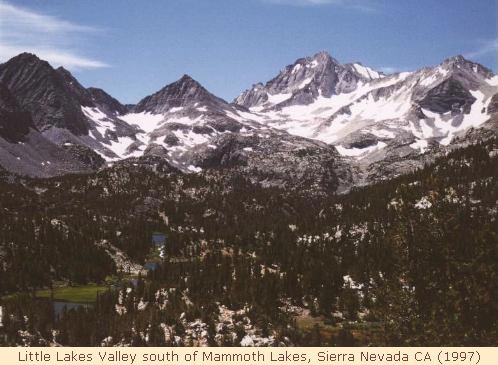
Silver Pass '97 - backpacking with Jim and Larry

the Cast

Just two of us on this trip: my brother Larry and me. He had a great deal of hiking experience in the Pacific Northwest, but this was his eagerly-anticipated first visit to the Sierra. This was my third visit to the Sierra (fourth, if one includes the limited result from 1993).

the Plan

The original route was a seven-day journey over Mono Pass to the John Muir Trail, then north over Silver Pass to Tully Hole. A right turn would take us over McGee Pass to Big McGee Lake, where we would cross over the undeveloped route of Hopkins Pass to the Mono Pass trail again. [I had the reassurance of a veteran of Hopkins Pass that it would not prove too difficult for us.] Seven days allowed for comfort, a bit of exploration, and plenty of adventure. A few side trips were included, and plenty of time was available for Larry to fish along the way.

the Revised Plan

Instead, we shortened the trip to six days. In order to depart on day six, the camps had to be shuffled. Big McGee Lake now would be camp four, so camps two and three were spread out to reach McGee Lake comfortably on the fourth day. This meant a long day two, but it would all be downhill to help us adjust to the distance and the elevation. Day three would be a bit shorter but had a good dose of elevation thrown in, and day four would be tough but not as hard as the previous days. Since we felt no great need to end day six at the car [i.e. spending Saturday night looking for a motel], we planned to exit early on day seven and drive back into Oregon for that night. Larry was planning on a one-day fishing license, so we selected day three [along the optimistic-sounding Fish Creek] for the best place for fishing. Checks of the ten-day forecast models looked very good, with north and west airflows over the Sierra. Southeast winds [monsoon] are almost always bad news in the sierra, and south winds [tropical storms, pm thundershowers] are potentially unpleasant. The forecasts showed none of that.


the Trip

The drive to Susanville went smoothly, and the swimming pool and cheap steaks [$6.95 filet mignon] were pleasant bonuses. We picked up a few last supplies before heading out. Sunday afternoon found us at Mammoth Lakes ranger station, where a stern ranger warned us of bears, bugs and biting flies. In a distressing evolutionary leap, the bears had apparently learned to follow backpackers, untie ropes and cut down trees, since she warned us that only the bear-proof containers were recommended for food protection. I was worried but Larry was skeptical, convinced that the ranger was giving us the worst news to keep from sending unprepared people into potentially unpleasant circumstances. We hit several stores before we found Larry a one-day license; the UPS strike struck again, leaving several places short on permits.
We finally skipped out for the road up Rock Creek, arriving at the trailhead around 3pm on Sunday. We found the walk-in campsites closed for vague reasons, so we retreated to the $12 sites at Rock Creek Lake. After saving a spot with our expendable stuff [the camp hosts told us a bear often visits the campground], we day-hiked a few miles up to Kenneth Lake, in a valley just east of Rock Creek Lake. It was a pretty hike, and it helped us acclimate to the 10,000-foot altitude. We had a great salmon-pasta dish, then tried out the small tent - crowded but effective.


Little Lakes Valley


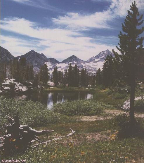
tarn along Mono Pass Trail

Day One: We started late, re-packing our gear and finding the main parking lot full at the trailhead. Once under way we enjoyed the wondrous views up Little Lakes Valley, which terminates in a wall of 13,700-foot peaks. Since the trailhead is over 10,000 feet it doesn't sound like much, but the walls around the valley are extremely beautiful! We moved slowly from both the strain of packs and the photo-ops but finally reached Ruby Lake, where we shed the packs and strolled up for the great views. Re-shouldering our burdens, we zigzagged up to Mono Pass at 12,050 feet. The views are limited at the pass, but after turning the corner below Summit Lake the northward view was a shock. Several multi-hued peaks pierced the cirrus-strewn sky, appearing too steep to remain upright: Red and White Mountain, Red Slate Mt., and Mt. Baldwin were extremely photogenic. One of our day-trips was to reach the summit of Red Slate; from our first view we knew that would be asking quite a lot, since it looked steep and slick with sliding rock. That was for a later time; for now it was time to get low and find a camp to rest our weary bodies. By 6pm we were at the end of the steep stretch, sitting at just over 10,000 feet on Golden Creek. Larry hunted upstream for a campsite while I forced oxygen out of the thin air. He found a great one close by, and the fire did us both good. Dinner was a hearty chicken stew with a spot of tea from Larry's supply.

Day two: My snoring drove Larry in search of quieter sleeping-quarters, and he woke up feeling the altitude. I felt worse on day one and a bit better this day, but the view west was disquieting. At 8am large cumulus clouds were already visible and drifting from the south. Some tropical air had apparently outflanked the 10-day forecast and was building towering clouds very early in the day. We filled up as best we could at breakfast, then headed down the long trail that a six-day schedule required of us. The thunder waited for us to reach the relative safety of taller trees before grumbling overhead, and a heavy shower passed behind us as we worked our way down-valley. The aftereffects were less pleasant: we toiled up a short slope under heavy, humid air that held neither cool breeze nor refreshing rain. We were again wearing out when we joined the Muir Trail in its northward march to Pocket Meadow. We stopped at the first possible place, but again Larry's scouting skills found a better site a few minutes ahead. Dinner this night was a turkey tetrazinni; I must have been tired because I still can't clearly remember how good it was. We also threw in some soup, which our bodies made good use of. I started the night without the rain-tarp under clear skies but awoke to more fast-moving clouds from the south at 4am. I hastily covered the tent and warned Larry, who was peacefully resting among the trees. No rain found us overnight, however.


view S from Silver Pass


view W from Silver Pass

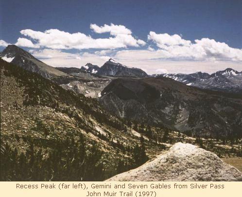
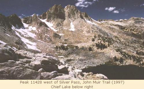
Day three: Eager for the high-elevation views, we resumed the tour around 8:30 after Larry tried out his one-day license on the local fish. Climbing rapidly past a pretty waterfall, we leveled out in a meadow with a sluggish stream full of fish. The hike was cutting into Larry's fishing day, and the promise of 'sometimes excellent' fishing at Tully Lake kept us (him) moving. We cleared the trees near Silver Pass Lake and met our first and only person doing the entire 200+ miles of the Muir Trail there. Climbing past the lake we encountered stunning scenery at the top of Silver Pass. We must have been stunned, since we didn't move from there for at least half an hour! After dozens of photos in all directions, we plunged over the north-facing snowpatch and descended into the Fish Creek drainage. A long, dry stretch followed with occasional views of the Minarets and Mt. Ritter / Banner Peak, leading ever downward to the upper fork of Fish creek. We resumed climbing at the fork, reaching Tully Hole in midafternoon. We could have comfortably stopped anywhere past Tully Hole, but Larry's mind and feet were set on Tully Lake, so three more miles stretched before us. The first crossing of upper Fish Creek was on a huge log, so we were shocked when the second crossing was wide open, with no log to be seen. We found a narrow, shaky, knot-covered one a bit upstream, and it brought my minimal training clearly to mind. Undo the waist-strap, protect your valuable things from the water, those kind of things. A clump of shrubbery on the other side called to me, and I tossed my water-bottle pouch across the narrow but deep creek. It landed so gently that I couldn't resist the potential danger, so I g e n t l y tossed my camera into the same place. It bounced off the shrubs, rolled down the hill and plopped into the creek, bobbing gently while it filled with water. I shot across the log hastily and scooped up the camera case, cursing my luck and forgetting how tricky that log was to cross. Winding the film and pulling the battery, I opened up the camera and put it on my pack in full sunlight, and waited for the results.
The trail steepened in a hurry, draining our last calories in the late afternoon, then leveled out near 6pm when we reached the Tully Lake cutoff. Crawling over large talus and up steep meadows, Larry reached the lake quickly and found us a high campsite while I crumpled at the shoreline. A few minutes later we were setting up camp above the lake near a lazy inlet stream, with Red Slate Mountain dominating the northeast skyline. That could wait for tomorrow; tonight's task was to keep the reluctant water-filter pumping while Larry used his fishing license before sunset. The camp was ready for him when he came back at dusk with two 10-inch trout [two more got away], so our noodles and chicken was well-supplemented by pan-fried trout that night. The bear problem was still on our minds, so Larry started a small fire to burn the leftovers while we scrubbed the fish smell off our pots and faces. My gloves smelled a bit fishy so I left them well away from the camping area. It was fully dark by this time, so we watched the stars for meteors [we never saw a one on this whole trip..] before going to bed.


Silver Divide from McGee Pass Trail


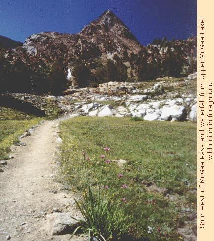
peak and waterfall near Big McGee Lake

Day Four started cold. My feet were cold all night, and the ice in the water-bucket gave a good explanation for our slow start this morning. We could finally afford it: this day's work would be less than five miles, although we did have some vertical distance to cover to reach 11,850-foot McGee Pass. Larry took some sunrise shots while I pointed my photo equipment at the sun [fog between the lens-elements told me that it was still holding water]. While I failed to see Larry's ballet act, he came back with an impressive gash on his leg from rolling gently off a chunk of granite. We covered the Tully Lake trail much faster this morning, then turned east into a scenic wonderland. High meadows, wildflowers, the red slate from the well-named peak, and the ragged crest of the Silver Divide combined for a morning of exquisite views and active cameras [I was improvising with meter-readings from Larry]. After a healthy climb we reached the top and huddled on the far side to evade the chill wind that had ushered us to the pass. Others coming up the east side noted that several snowfields awaited us on the downslope; after a bit of lunch we confronted the large patches and negotiated a safe descent.
Looking at us from the south side of the valley, Hopkins Pass sported large snowfields of its own, crowned with a huge cornice. The look of that was decidedly unpleasant, and we spoke of our few alternatives to that route. Only one option, really, and it took us down the wrong valley to a spot both remote and far from the car. In the meantime, the view opened up toward Big McGee Lake and the rest of the valley. We reached the lake and turned toward Hopkins Pass, looking for a good camp and a place to examine the pass more closely. A beautiful camp awaited us under the pines near the smaller lake, and our 3pm arrival left us with time to relax and clean everything we possessed. I chose the stream for refreshment and Larry chose the big lake; he reported a 16-18" trout sharing his swimming area!
Since it was our niece's birthday we splurged on dinner, with Chicken Rotelle and tea or punch followed by soup and a chocolate mousse pie for dessert, followed by a Yukon Jack toast [we had sampled the liquor each day to be sure it was safe to drink]. Larry went up-valley afterward to check tomorrow's route while I turned in early. He learned several things, most notably about how not to cut willow saplings: his finger bled a lot longer than he thought it would.

Day Five found us up early, eager to confront Hopkins Pass. It certainly wasn't do-or-die material, but it was easily the best way to close the loop ["tighten the noose" was how I put it] and reach the car in six days. The early part of the hike was on a clear path, steep but reasonable, with great views down McGee Creek. The route appeared to turn left at a small tarn on the map; we found the tarn but were decidedly taken aback by the route. Encased in a huge snow-filled basin, the tarn had large radial cracks in the surrounding snow for added suspense, and a 50-degree-plus slope of icy snow led to the cornice. The only relief was the two equally-steep rock bands that cut across the snow. We reached the lower rocks and shed our packs, with Larry again taking the point for reconnaisance. His speech at the end was decidedly uninspiring, so after muttering a bit about disliking both up and down options, we chose to retreat. Five minutes of eastward traversing brought us to a much more favorable approach to the pass, and with minimal discussion we charged upslope to the rocks again. Larry used a chunk of slate to cut steps in the snow, then traversed left on the rock band and found a snow-free trail to the very top while I enlarged the snow-steps. He came back with the good news and improved the steps on his way down to the packs. We scampered up the slope [steep enough in places to go on all fours without bending over] and stood triumphant on 11,400-foot Hopkins Pass. It was nearly noon then, so the 1½-mile trip took about four hours of work, thought and determination to complete. We felt GOOD!!
After a few 'team photos' we began working our way down the east side of the valley, where the trail surely must have gone. While we found a path in places, its usefulness as a guide was very poor. It did, however, lead us to two ptarmigan that were as surprised by us as we of them; they moved to some nearby rocks and stood still, hoping we would forget they weren't stones. The map showed three good-sized 'Upper Hopkins Lakes' but our eastward route gave us no views of them. We hoped to find a way to lower Hopkins Lake for the night, but the lack of a clear trail was draining our energy much as Hopkins Pass had worn out our creativity. By mid-afternoon we reached a trail that crossed our path; daring to presume it was the trail to the lower lake we took off gratefully. When it turned sharply uphill we began to doubt, but it finally wandered off south and hit the lake. The insects enjoyed our company far more that we did theirs, and we finally found a large, comfortable horse-camp on the south side where the bugs were fewer. Another refreshing dip followed, and the fire and meal were first-rate despite the few but ravenous bugs. This night was teriyaki chicken and rice, followed by a cheddar-potato soup; both went down very well indeed.

Day Six: We were now just where we had hoped to be, within a long walk of the car but willing to stop short at Ruby Lake. A few clouds passed by when we began, the first we had seen in two or more days. On the Mono Creek trail again, a few people passed by, the first we had seen since McGee Pass. We found that we could still communicate with others and learned that Pioneer Basin was a crowded place, with mosquitoes, several groups of campers and a couple of dogs competing for space. We had hoped to visit there from Hopkins Pass but chose the easier path; the decision was therefore a good one for both simplicity and privacy. We passed several others heading toward Pioneer Basin; we didn't have the heart to tell them of its popularity. By the time we passed the Trail Lakes, dark clouds with evil intent were gathering in several parts of the sky, but their turmoil produced a pleasant by-product: lenticular clouds. I had often heard that these clouds were a common sight in the Sierra but these were my first in four trips. Their flying-saucer appearance hovering over multi-hued Mt. Baldwin was especially unearthly.
We reached Summit Lake after 1pm, and people and clouds reached a maximum density there. This group was on an 'ambitious' schedule [that was how others described our route early on], heading for Gabbot Pass and the Bear Lakes Basin before crossing east again at Pine Creek Pass. Their route would parallel my '96 trip to some degree, so it sounded like fun - and hard work! The rain hit us indirectly at the lake, so we dressed up and crossed the pass in haste. The clouds were disappointed in our reaction, so they pelted us with ten minutes of hard rain with small-hail for variety, especially unpleasant for Larry's unprotected legs. We were on the downslope to Ruby Lake when we began to discuss our options: "we could be in Reno tonight, or sleeping on wet ground under threatening skies... hmmm". That was one of the easier decisions on our trip, so we redirected our energies to reaching the van and the long highway home. We hit the road about 4:30, after dipping the ceremonial beer in the creek for ten minutes and letting our bodies readjust to the carbonated world.


Epilogue: I won 120 quarters in Reno that night after the cheap New York Steak, while Larry's luck waited for the next morning. I gave most of my winnings back, but Larry parlayed five chips at craps into nearly twenty, then took three to the slot machines and picked up twenty more! The long day's drive brought us back to Portland by nightfall on Sunday, eager to sit somewhere soft and tell our tales to any who pretended to listen.


If you enjoy the Sierra, you really should own this software!