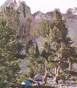
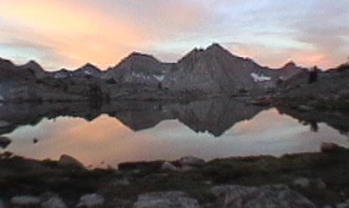
looking north at camp one
PREPARATION
My co-worker Scott had Lamarck Col on his wish list for ten years or more, and several previous trips came close without reaching it. My ankle pain forced us to turn toward the car in 1996, depriving him yet again of his goal. Whatever else 1999 held, it would be less than succesful if Lamarck Col was not attained! He preferred it to not be the first day's work, however - but also not the last, for fear it would be missed again by injury, weather or other misfortune.
My preferences were a touch different. While I have not seen much of the Muir Trail, I was focused on the adjacent valleys that see less travel and equal beauty. Several books and web pages brought Marion Lake to my attention, and I looked for east-side routes that would bring Lake Basin within my range. As our two ideas came together, a route from Taboose to Lamarck took shape; at around sixty miles, it would be a challenging week! Scott was concerned that Lamarck would be at risk on the last day, but I assured him that I would exit early by myself if it gave him the best chance to reach his goal.
Both of us were concerned that this cross-country route would be more difficult with our aging external-frame packs, so a local sale on Lowe Contour packs was welcome to us both. Scott added a new sleeping bag and water purifier, and I picked up a new fleece vest to replace my ancient nylon/polyester one.
the Plan: as far as possible on the Taboose Pass trail
We left the Ford Escort at North Lake and took Scott's truck to the Taboose
trailhead. Several changes had taken place since we last visited ten years before. The road had fared badly in the '90s
- we drove a VW Rabbit in 89 but found the road challenging in Scott's small
pickup this time. The good news came an hour or so into the hike, where we
found a rest-stop carved into the streamside willows. Our previous trip had
been a very thirsty one, and the willows had not allowed access to Taboose
Creek; now water and shade were available, and very welcome! Two hikers from
Virginia were also there, looking for a ride out; we told them of their bleak
prospects at this relatively desolate road-end, wished them well, and continued
back into the hot sun. We passed the Tree Bench (this route passes five benches
- cliffs, really - each with a reasonably prominent landmark), then the
Waterfall Bench late in the day. We found a couple above there setting up camp,
and they indicated other sites nearby. This was very near our 1989 camp, and we settled in for the night. This
couple was also planning to cross Cartridge Pass, and their hints for that and
for Lamarck Col were welcome. A cloud briefly dropped some drips on us, but it
relented before we became worried about it.
For unclear reasons, the Wilderness Reservation Service seemed rather insistent
that we cross the pass for our first night. This was puzzling, and downright
mean to full-pack folks who would feel the effects of such a climb for days to
come. Our camp-mates heard no such advice from the rangers when they grabbed
the last day-of-hike permits, so it clearly was not as big a deal as we feared.
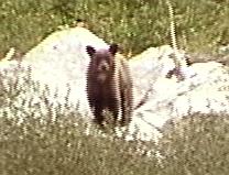
the Plan: cross Taboose Pass, descend the South Fork Kings, climb to lakes below Cartridge Pass We awoke to clear skies and departing neighbors. After breakfast we continued up to the Rapids Bench, then the Grey Bench. A hiker who had started from the trailhead at 6AM passed us here, obviously making very good time! We finally passed the Green Bench and reached the pass late in the morning. After photos and rest we continued down, veering north to reach the Muir Trail near the crossing of the South Fork Kings. We took a long lunch break along the way, then continued down to the junction. Apparently our campmates left us a note in the dust to help locate the Cartridge trail, but at the junction we met others and talked as we walked and missed the clue. At the crossing of the South Fork we turned downstream, and within five minutes hit the clear path we had hoped for. It disappeared after some blowdown and a patch of talus, then reappeared again. In the second talus I met my first bear, who was examining the shrubs on the river's south bank! I spoke to him and pulled out my video camera; he shifted nervously, which made me far more comfortable, then he shuffled out of sight into the shrubs. After that talus we had hints on recovering the trail from DW Donehoo's web pages, but it was late and the trail was subtle. We finally decided to camp at the South Fork, and we found a nice camp. The young bear did not visit us, nor did any of his relatives. Another cloud popped up and hit us with late-day drips, but not enough to get anything wet.
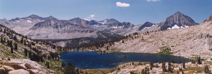
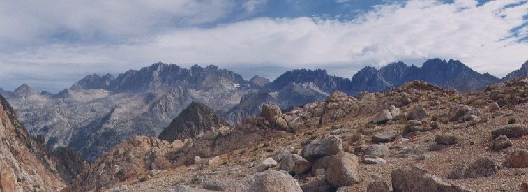
the Plan: cross Cartridge Pass, visit Marion Lake, camp in Lake Basin We were a bit behind schedule now, so Scott arose early and uncovered the faint path that would lead to Cartridge Pass. We climbed steeply up the switchbacks, occasionally losing the trail but not for long. It stopped at a talus pile, but after a dead-end or two we found it traversing west to another set of switchbacks. We finally reached the pretty lower lake, where the trail eluded us again. We regained it above the lake, and more hard climbing brought us to the summit. The view south was extremely pretty, with Pyramid and Arrow peaks standing out against the sky (which was again filling with cumulus clouds). The north view could be called a disappointment in comparison: the tall peaks showed little character on their south sides, just long slopes of talus above the highest Lake Basin lakes.
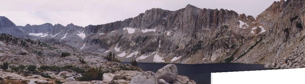
We found the north side trail to be as bad as DW had described - a long, steep slope of rock and gravel that had been carved into many paths of dubious quality. Many people had gone straight down, which damaged the more relaxing switchbacks and made all routes more challenging. We finally made it to the first lake, where we encountered our camp-mates from Taboose. They had reached the first lake on the south side the previous night but were exhausted, so we were able to catch them this day. We spoke a while, bid them farewell, and immediately lost the trail. We veered right in search of it, but apparently crossed it during a faint stretch and found ourselves well to its north. Since our route to Dumbbell Pass required us to go north the next day, that was no real problem! Scott led us down a steep wall to the northern L-shaped lake in the basin, and we found a great camp near the lake. This evening actually had thunder, but no raindrops interrupted my dinner for once.
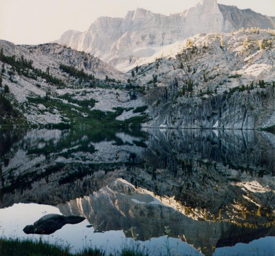
the Plan: cross Dumbbell Pass and Cataract Pass, descend to Muir Trail at Deer Meadow We awoke to more clear skies and took a quick tour of Lake Basin. We went south and passed more lakes, crossed a stream and a ridge, and dropped due west to Marion Lake. A woman was camped at the lake, and we dropped in for a few minutes to chat. She was a ranger at Ceadr Grove and had traversed Cirque Crest before dropping to the lake from the south, a route that looked and sounded quite challenging! After that we searched a while before finding the memorial plaque several yards west of the outlet stream. Several wildflowers bloomed around the rock with Helen Marion LeConte's plaque on it, adding to its charm. We then took the trail from the outlet stream toward the old JMT but lost it quite rapidly. We went by the easiest way and soon met our earlier route between the lakes, retracing our steps to camp and breakfast.
From our camp it took only two hours to reach Dumbbell Pass, which was a beautiful scene. Through its narrow gap to the northeast was framed North Palisade and Mt. Sill, while Marion Peak was centered in the southwest. We then worked our way cautiously down a snow-slope to the right, stepping off into a field of huge and spooky talus. We could not see over the edge of these massive blocks, so we moved cautiously right until reaching a slope of less precarious angle. The famous Secor book said to go around the first lake on its west side, but it took a lot of work just to reach the lake at its southern end. Despite our next pass showing clearly around the east end, we obediently worked our way west, looking uneasily at another afternoon of mean cloud build-up as the lake continued to turn us left. We then reached a spot that the topo map implied was a cliff into the lake, and so it was. A few minutes of class-three work (hand-holds REQUIRED!) put us back on familiar rough talus, and we finally cleared the lake after a long two hours' work.
We then headed north toward lower lakes and trees and found several whitebark-pine screens to hold back the gusty winds. Our camp was near 11000 feet, and we were chilly but undampened, the harsh clouds overshooting us yet again. We saw no evidence that anyone else was in this basin while we were there.
the Plan: irrelevant by now - we should be on the Muir Trail! Clearly, we were well behind schedule again, since we had not crossed Cataract Pass. Bill Finch's web page implied that Cataract was the toughest pass he had crossed in the vicinity, and after our experience at Dumbbell that caused a lot of concern on out part! Nevertheless, we swiftly worked uphill to the pass, reaching it in less than an hour.
Our view to the NE was one that confirmed his experience: a near-vertical snowfield blocked the direct route, and only part of Amphitheater Lake could be seen below us. It would indeed be a tough few hours coming up! On the other hand, the view of the Palisades was even better than from Dumbbell Pass, and the gentle notch of Knapsack Pass was clear below Columbine Peak to our north. Whatever came next, the view was a special one.
We worked left around the snowfield, then crossed it at a level point and continued attacking the talus on the right side. We finally reached a patch of green, went right again and worked down to the lake, where more large talus kept us hopping to the very north edge of the lake. While I had hoped that we would camp here so I could explore the basin to the SE, a few glances and pictures were the best I could do this trip.
After rest and a quick meal, we headed north in search of the old path down to Deer Meadow. Secor said the basin above the trail was 'easy', but again we were forced to disagree with his evaluation. Many ramps both left and right led us down by the creek, only to force us higher again where the trees thickened just above 10000 feet. We were forced high and to the right, and we were questioning our sanity when we saw a large duck atop the ridge. From the ridgetop we found a small valley that ultimately solved the puzzle, with merely another large talus-field between us and the path now visible below. Although we lost it several times before reaching Palisade Creek, we were becoming accustomed to such inconveniences now; we simply went by the best way until the path chose to come to us again. A lot of blowdown near the valley floor led to more circuitous walking, but we finally reached Palisade Creek and rewarded our feet with a crossing of the chilly stream.
After a half-hour of head-shaking, eating and foot-resting, we recognied that we still had some walking time left. Since we were exiting at North Lake in three days, we resumed our travels on the hard-to-lose Muir Trail. After some time we reached the junction of Palisade Creek and the Middle Fork Kings and set up camp. For the first time since day one, we were not alone: two couples shared the camp area with us, and others were in more secluded spots nearby. No rain intruded here, and a group of four mule deer wandered through the area at dusk.
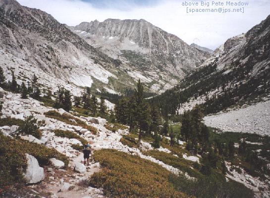
the Plan: somewhere northwest of Muir Pass After breakfast and a conversation with one of our neighbors, we moved upstream with the Middle Fork. We were seeing a great many people on the trail, and a large percentage of them were doing the entire Muir Trail this year. When we reached LeConte ranger station, we met the ranger at his cabin as we ate a meal nearby. He noted that three 'bad bears' were in the area, noting Dusy Basin and the area around Big Pete Meadow as high-risk spots. We were planning to be well above Big Pete, so we continued uphill. A group of eight or so were matching our pace, doing the South Lake to North Lake tour. We sped up and were alone soon, but we were soon overtaken by now-familiar storm clouds. These looked serious, so we sought a place to hide near the lowest lake in the upper basin. By the time we found a good place the cloud had blown by (on its way to drop snow on hikers at Muir Pass), and blue sky was appearing again in the south. Pleased by our good fortune, we continued up, passing a camp with three llamas grazing in a small meadow. We continued on to the next high lake and found room for two tents well above the water.
The weather was having a rather serious effect on our wash routine by now. Each afternoon had been cloudy and cool, so we were forced to delay washing clothes until at least one other outfit had a chance to dry. We again washed some things and hung them out, and this time the late-day sun was actually able to dry an item or two.
After dinner I wandered back down stream to visit the llama camp. I suspected that the woman camped there was an acquaintance from the Yahoo! outdoor clubs. She remembered me as the one who sent her images of llamas from my 1998 hike in the Wind River Range, and we talked for quite a while about our travels. I then returned to camp where Scott and I each had a lousy night's sleep despite our weariness.
the Plan: get to Darwin Bench in preparation for Lamarck Col exit Our schedule had mutated a bit, but by bypassing a few spots we could still reach Darwin Bench as planned today. We packed up early, beating the large group that had also reached the lake, and moved upward toward Muir Pass. The sky was again a perfect blue, but our poor sleep didn't help our pace much. We passed a few campers at Helen Lake, then they passed us near the top. The view from the Muir Hut was an interesting one, as ugly clouds were clearly visible in the western valleys while the weather overhead was perfect! Apparently another pocket of cold air had moved along the Pacific coast and was spinning offshore; had it been a little closer our suffering would have been great, but it was our lucky day. We visited the hut and relaxed a while, then strode downhill past Wanda Lake and several dense clouds of gnats before turning the corner and getting the perfect view of mts. Darwin and Mendel above Sapphire Lake. We ate a bit at Sapphire Lake, then cleaned up some at Evolution Lake before taking the detour toward Darwin Bench at the first steeply downhill switchback (as noted in several, but not all, guidebooks). We kept with tradition by losing the trail several times, but continuing on our way until it found us again. We passed the lower lake, reached the meeting of creeks from north and east, then headed uphill to find ideal camps among the whitebark pines. This day was still clear and warm, so we washed everything in sight even though we had only one more day of work ahead.
By this time it was becoming clear that our second adventure beginning at Bishop Pass was in jepoardy. My left knee and right ankle were quite sore, and Scott wasn't at full strength either. His plan was to return to his car at Taboose via Bishop Pass, going x-c and climbing Mt. Sill and/or Split Mt. along the way. If he was too tired to climb - and the view of Mt. Sill from Cataract Pass was clear in his mind! - why not take that hike another year? We hadn't explicitly stated that the second trip was off, but thoughts were turning that way...
What was NOT clear at the time: my camera's shutter was badly out of sync, rendering most of my images unviewable...
After cleaning our selves and clothes, we snuggled into our camps behind the pines and slept well. The temperature was warmer this night despite less wind and a camp at 11300 feet!
the Plan: exit via Lamarck Col to North Lake, then clean up and reload for Bishop Pass!
Back on schedule at last!
We were up early again, hoping to get out before the weather reconsidered its recent behavior. At least one guidebook suggested that the first lake in Darwin Canyon should be passed on its south side, but the terrain north of our camp seemed better to Scott, and after a short while the path joined us there as well. We met another couple at the upper end of lake three; one of them had been this way ten years ago. We gave them a head start for their privacy and our guidance, then circled lake four. They cut left before the top of lake four, but we stuck with the path that nearly reaches lake five before turning north. As at Cartridge Pass, several paths ascend through the scree here, and losing one path merely meant finding another a minute later. It was a long trudge, but we finally gained Lamarck Col around 11AM. Although this is characterised as a cross-country route, the Park Service informally recognizes it by putting up a sign announcing one's arrival in Kings Canyon NP. Scott did not think the route would be so well-beaten; as it turned out he hadn't seen anything yet!
After celebrating our victory over his long-deferred route, we prepared to descend. Noting that the couple ahead of us had moved away rather slowly, we now discovered why: once again, a steep snowfield followed by large talus intervened. Scott chose to cross the snow into the rocks quickly, while my walking-stick gave me confidence to descend further on the snowfield. Unfortunately, I crossed into a rock-field with ice between the boulders, and a short skid further torqued my knee. We reached the flat slopes, weaved through flat talus, and began meeting a group of nine Arizonans on their way up to the col. I wrapped my knee in an elastic bandage and we continued down, avioding the two turns that could leave one hanging well above upper Lamarck Lake. We caught views of Grass and North Lakes and began to descend into the narrow valley, but a quick view of the topo map showed that it was time to turn left toward Lamarck Lakes. A faint path appeared in a dusty flat to the left, and we worked over that way. It then turned west and began a harrowing traverse above the valley to Grass Lake; I could not look over the edge without a touch of vertigo so I focused intensely on the narrow path. We then reached a crest and began an interminable switchbacking descent to a good trail below. At this point Scott openly questioned everything he had heard about the Lamarck Col "route", which was a clear path through absurd terrain rather than a vague path over obvious terrain. On the other hand, I was limping gently downward, grateful that the end was near.
Once on the clear path, we spent a rather obscene amount of time going uphill to lower Lamarck Lake. I commented that, at our rate of descent, we would NEVER reach the car! The trail finally dropped a bit, crossed the stream twice, and.. ASCENDED again!! Scott found a faint downhill path, but I suspected that we wanted the newer uphill trail, and he relented. Between lower Lamarck and Grass lakes the downhill finally came, and my knee was quite displeased. I met a young man cruising uphill with Lamarck Col on his agenda; after a bit of talking he noted that I was nearly out, since he was 30 minutes on the trail. Much to my dismay, it took me 40 to reach the trailhead, where Scott had been waiting a while. He went on auto-pilot for the last hour and reached the first picnic table exhausted and overheated. After a short rest, we hiked down the road to the hikers' parking lot, piled in to the Escort, and rolled merrily down to Bishop.
The 1999 Sierra hike was a close match between ambition and solid rock. This trip was exhausting physically, mentally and meteorologically, with no easy days or relaxing afternoons. Our delays in the trackless wild meant more speed on the Muir Trail, and random afternoon showers kept driving us forward toward shelter when we could have used the time off. In the end, however, we successfully completed our route and met all challenges. That's always a good feeling, and we're proud of our endurance, pathfinding abilities and flexibility under stress.
On the equipment side, all worked well. My last-minute decision to use only my rainfly for shelter was a great success, with very few bug-bites resulting from it. Our 32° sleeping bags were decidedly inadequate for camps above 10000', but we managed. I highly recommend AlpineAire's "Sierra Chicken" dinner, with their "Wild Tyme Turkey" a close second. The Lowe Contour IV packs performed well despite our external-frame background, stoves and filters worked great, and my new bear canister saved me several minutes of hassles each day for less than three extra pounds. We had a great time, saw amazing scenery, and survived in reasonable comfort to tell about it.
I've had troubles with imaging gear on occasion, and this trip was no different. I had hoped to replace the semi-fisheye video conversion lens with something less extreme, but I needed a step-up ring that I didn't have, so the video is less sharp than I had hoped (but with a very wide field, the 35mm equivalent of a 21-210 zoom).
The day after the trip ended, my 35mm SLR jammed. Later developments proved that it had in fact died on day seven, very near Muir Pass, so many unique images of the snow-free summit are forever lost. Several fantastic images of Evolution Lake, the following sunrise and Lamarck Col also eluded me. Fortunately, the video camera lived on to preserve the memories, fuzzy or not. Scott's new Pentax compact camera did its job well, so a few of his images fill out my last days!